Annals of Environmental Science and Toxicology
Trends in the Tourism Sector of Kyrgyzstan and Problems of Nature Conservation in its Mid-mountain Zone
ET Toktoraliev1*, DA Beyshenkulova2, BU Abylmeyizova2, TK Toktokozhoeva2, TM Choduraev1
1Kyrgyz State University named after. I. Arabaev, Bishkek, Kyrgyzstan
2Kyrgyz State Technical University named after. I. Razzakov, Bishkek, Kyrgyzstan
ORCiD : DA Beyshenkulova: https://orcid.org/0000-0002-4865-6266
ORCiD : BU Abylmeyizova: https://orcid.org/0000-0002-7250-2881
ORCiD : TK Toktokozhoeva: https://orcid.org/0000-0001-6220-5720
ORCiD : TM Choduraev: https://orcid.org/0000-0003-3051-9295
Cite this as
Toktoraliev ET, Choduraev TM, Narkeeva NZ, Beysenkulova DA, Tusupbekova AT. Trends in the Tourism Sector of Kyrgyzstan and Problems of Nature Conservation in its Mid-mountain Zone. Ann Environ Sci Toxicol. 2025;9(1):001-005. Available from: 10.17352/aest.000083Copyright
© 2025 Toktoraliev ET, et al. This is an open-access article distributed under the terms of the Creative Commons Attribution License, which permits unrestricted use, distribution, and reproduction in any medium, provided the original author and source are credited.The article is devoted to the study of the dynamics of the tourist flow in the territory of Kyrgyzstan, amid socio-political and economic uncertainty , and the study of preventive measures to preserve resources. Its relevance related to the pace of development of this industry in the territory under consideration, which depends on its geographical location, features of external components, acting as factors of attractiveness of vacationers and in the future can negatively affect the preservation of this territory.
Identified the main consumers of tourism products in Kyrgyzstan, these include neighboring countries . The number of recreants increases with the development of educational tourism, attracting people from China, India, Pakistan, etc. countries - the main consumers of tourism services.
Field studies involved direct landscape measurements and theoretical justification of the recreational opportunities of the middle zone of the region, which is the most attractive for tourism development.
For the development of this sector, taken into account such factors as the sustainability of ecosystems. Have been conducted field studies for various types of landscapes in mountainous areas, taking into account the structure of its territory, slopes, weather conditions that affect the degree of degradation, which affects tourism and recreation.
Established standards for specific types of landscapes, which substantiated by natural measurements in specific areas.
Methods for calculating the one-time capacity of the studied territory are proposed .
Introduction
Kyrgyzstan, located in Central Asia, is one of the attractive places for tourists from near and far abroad, where in 2022 alone about 6 million people vacationed, among which foreign tourists account for 4 million 993 thousand people. The main consumers of tourism services are citizens from neighboring countries, mainly our neighboring states - Uzbekistan, Kazakhstan, Russia, Tajikistan, Turkey, Azerbaijan, Belarus, etc. [1].
The relevance of the research topic is related to the economic possibilities of the activity under consideration, which directly affect the ecological state of natural resources.
The primary focus of the study is natural attractions favored by tourists, particularly mountainous regions, which feature diverse landscapes ranging from semi-deserts to steppes, mountain meadows, mountain-meadow-steppes, and glacial-nival zones.
The objective of the study was to determine the recreational potential for mountain areas with different slopes and subject to different weather conditions.
The achievement of which is ensured by in-kind measurements of landscape indicators of mountain areas in various weather conditions, primarily for the warm season of the year (April – October).
The materials and methods of the research included the collection of data on tourist flows, analytical and theoretical justifications of the tourist potential, the study of stock and statistical data on the problem under study, and the conduct of field and office work to establish the recreational potential of the areas used.
Theoretical part
The contribution of tourism to the economy of our country depends on many factors – political, economic, social, medical, natural, etc.
As the dynamics of the tourist flow shows, their number increases annually, despite various negative factors of influence.
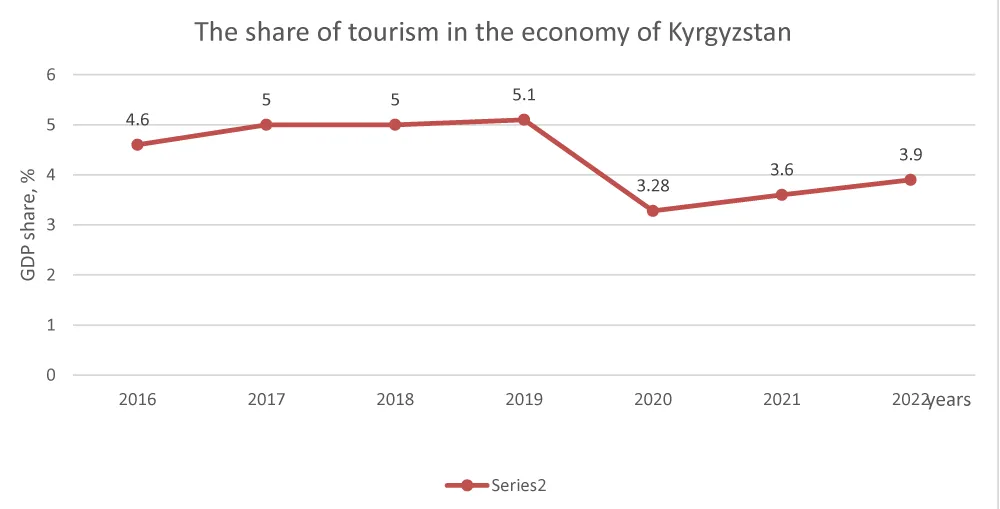
Figure 1 illustrates a clear decline in tourist numbers due to the 2020 COVID-19 pandemic and the whole world found itself in isolation.
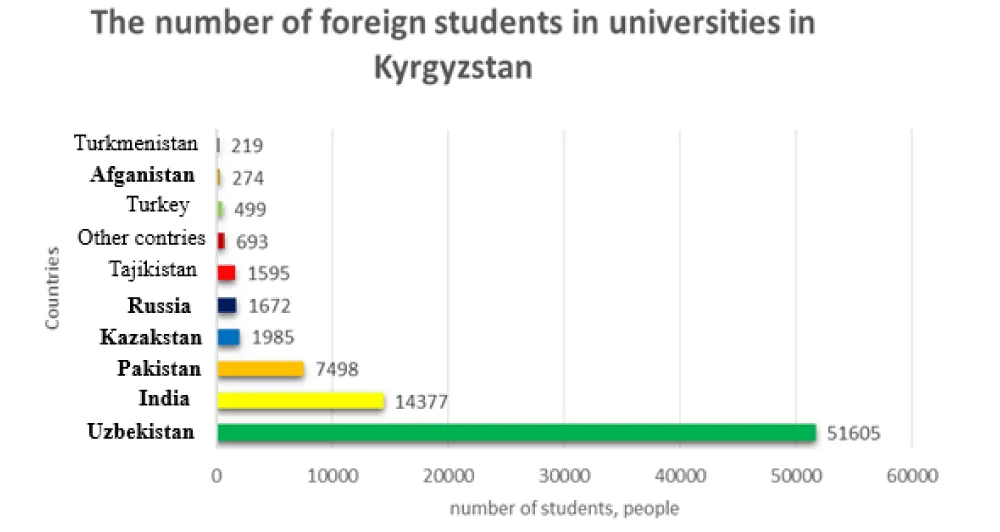
Listed countries are not only consumers of educational services, but also of other socio-economic objects, including tourism services.
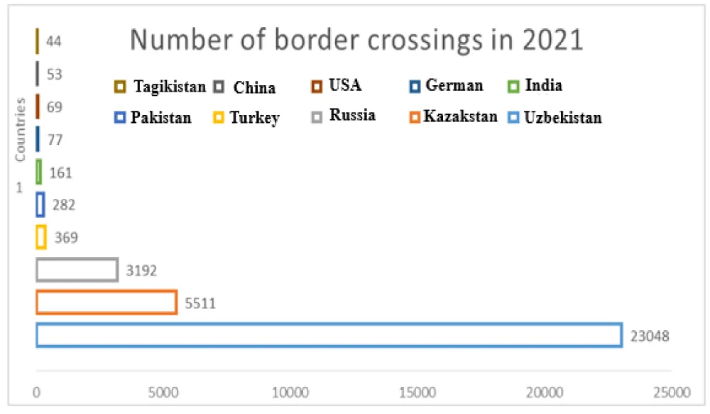
Analysis indicates that the primary consumers are our large neighboring countries such as Uzbekistan, Kazakhstan (Figure 2), which are determined by their geographical location and economic ties.
In recent years, there has been an increase in the flow of foreign tourists from neighboring countries such as India, Turkey, Pakistan, Afghanistan and Turkmenistan (Figure 3). This growth is due to the introduction of visa-free regimes, as well as the growing political will of the country aimed at developing tourism as the most important sector of the economy. However, along with this, there are problems of preserving recreational resources, which requires an accurate assessment of their potential and establishing the correct recreational load. Modern studies show that density standards for recreational areas can vary significantly. For example, for parks, density standards range from 40 to 120 people per 1 ha [2,3], for forest parks - from 10 to 25 people per 1 ha [4] and for forest areas - from 2 to 8 people per 1 ha [5]. However, these methods may have significant discrepancies in various indicators, which requires further research.
Similar studies of coniferous forests on shallow sands showed a density norm of 7 people/ha [7], which cannot be applied to areas with a certain slope. According to Chizhov [8], the maximum permissible norms vary from 3 to 20 people/ha, while the maximum permissible density for short-term recreation is from 7 to 50 people/ha, and for long-term recreation - from 2 to 18 people/ha. However, a key limitation is the reliance on average visitor numbers , which does not take into account seasonality and weather conditions.
Additional data on density for parks - from 30 to 150 people/ha, determined in the works of Preobrazhensky [9]; for forest parks - from 8 to 20 people/ha in the study of Promina, Kozlova, Sergeeva [10], and for forest areas - from 1 to 100 people/ha. This study by Vasiliev and Kukushkin [11] concerned areas with paved roads and special surfaces. The main drawback of these studies is that they cannot be applied to natural landscapes.
In the work by Dyukovan and Serikova [12] “Determination of recreational capacity and actual use of the park territories of the Foros resort complex” the ecological recreational capacity of park territories is established, adjusted in accordance with the standards for the maximum load at the third stage of recreational degradation. The use of such territories is most effective only within the framework of the proposed functional zoning of landscapes.
According to Ivonov [13], studying areas under constant recreational load provides more reliable results subject to constant recreational loads and the stages of recreational degradation are clearly distinguishable [13].
Research results
Despite the attractiveness of mountain landscapes, it was observed that these areas are particularly vulnerable to anthropogenic impact, under the influence of which erosion processes, degradation of individual types of biocenoses and other environmental changes continue. The most vulnerable are high-mountain areas, the most stable are lowland and temperate zones, but we propose to use mid-mountain areas, where mountain slopes clearly expressed, as well as changes in ecosystem components and economic landscapes [14].
The problem is to determine the recreational and tourist potential of these areas, capable of receiving a large number of visitors, which is expressed in their recreational capacity. The calculated load represents the average recreational capacity per site , but the disadvantage is that the assimilation capacity of the area was not fully considered [15].
The method for calculating the recreational load developed based on the five-stage degradation adopted in the CIS countries, which before independence [16]. Calculation of the capacity of recreational zones is necessary in order to understand under what conditions it is most effective to place rest homes and sanatoriums. In this case, qualitative and quantitative indicators reflecting the characteristic properties of the natural environment, which clearly manifested in the diversity of landscapes, are important. It is also necessary to take into account the building codes and regulations used in the design of buildings of this type [17]. In this study, the basis of the analysis is the sensitivity of landscapes in the territory of the studied recreational zones. For this purpose, were used “transectional” studies along various orographic structures of landscape belts, which allows us to assess the stability of phytocenoses. The results presented in Table 1 [18].
Calculation methodology
One-time recreational capacity determined by the formula:
N = S terr / S (1)
Where S terr – total area of the recreational zone, S – area required per vacationer.
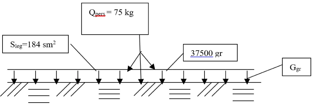
In determining the capacity of the mid-mountain zone, we used the “loading” method. In this case, experimental sections with a square base of 10x10 cm selected and tested to assess load-bearing capacity under simulated pressure (Figure 4).
The indicator was vegetation variability, in which a four-stage degression used:
I – no changes in vegetation cover;
II – growth retardation;
III - the beginning of color change;
IY – disappearance of individual vegetation species.
Based on this method, the pressure load was calculated as 8.76 g / cm2 for the mixed-grass areas of the study area. The average mass of a person (Q) is 75 kg.
By distributing the load on two legs with an area of 184 cm2, we obtain the load of a person at rest.
A moving person exerts pressure on approximately one-third of their foot area and therefore:
If we assume that the optimal soil resistance (gs) is 8.86 g / cm², then the difference between human mass pressure and soil resistance will be:
When calculating the area required for a vacationer, it is also necessary to take into account the slope of the terrain - φ and weather conditions - p, which will undoubtedly affect the stability of the areas used. Then the final formula will look like:
where: φ is a coefficient that takes into account the slope of the terrain;
- for 0 < α < 3; then φ = 1.0;
- for 3 < α < 10; then φ = 1.4;
- at 10 < α < 15; φ = 1.6;
- for α > 15; φ = 1.8;
- P = 1, in clear weather;
- P = 2, in rainy weather;
- n = 70 – coefficient accounting for the differential between body weight and soil resistance of the soil.
Using formula (5) we determine the area required for one vacationer. It ranges from 34.5 – saltwort and feather grass deserts to 491 m2 – coniferous meadows (Table 1).
For recreational purposes, mainly low- and medium-sensitivity landscapes are used, and the area per person will be approximately 300 m2.
Based on this standard (according formula 1), the one-time carrying capacity of the mid-mountain zone, such as in the Issyk-Kul basin, is calculated as follows :
N = Sₜₑᵣᵣ / S = (1.8 × 10⁷ m²) / 300 = 60,000 people ,
where, Sterr = 1.8 thousand hectares – area allocated for recreation in the mid-mountain area;
S = 300 m2 – area required per vacationer.
The one-time capacity is 60 thousand people. The annual capacity of this zone in this case will be 1,440,000 people.
For example, the Issyk-Kul basin occupies 22,000 square kilometers, and the area of Kyrgyzstan is 199,900 square kilometers, then the total recreational capacity of the country will be 5,400 thousand people. Moreover, the annual capacity of 129,000,000 people, which has great potential, to achieve this level requires substantial investment in infrastructure, facilities, and economic stability , the establishment of political and economic stability.
Conclusion
The conducted studies have shown that Kyrgyzstan has good potential for attracting tourists. Considering the possibilities of the natural conditions of this territory, one should not forget about the features of the objects used, including the special sensitivity of these areas to anthropogenic influence.
For sustainable development of recreational and tourism potential, it is necessary to identify specific opportunities for each territory.
Research has shown that the most attractive for tourism and recreation is the mid-mountain zone, which exhibits moderate sensitivity to anthropogenic pressure and its potential ranges from 10 to 216 meters, influenced by both altitude and terrain slope.
The capacity is also affected by the climatic conditions of the territory used. By incorporating slope, climate, and vegetation variables , it is necessary to determine the recreational potential and one-time capacity for each specific area, on which the preservation of natural components will depend.
- Chizhova VP. Recreational landscapes sustainability, regulation, and management. Smolensk: Oikumena. 2011.
- Ivanova NV. Recreational resources and their efficient use. Ecology Publishing House. 2020.
- Kuznetsova OL. Tourism and its impact on the economy of the CIS countries. Tourism Publishing House. 2019.
- Petrov VI. Environmental aspects of recreational planning. Science Publishing House. 2021.
- Smirnov SP, Agafonova MV. Sustainable use of forest resources. Ecosystem Publishing House; 2022.
- Kazanskaya NS, Lanina VV, Marfenin NN. Recreational forests (state, protection, prospects for use). Moscow: Lesnaya Promyshlennost. 1977;96.
- Ivanov AP, Smirnov DV, Petrov IA. Research of recreational norms on sandbanks. Ecology Publishing House. 2021.
- Chizhov VP. Recreational resources: theory and practice. Science Publishing House. 2020.
- Preobrazhensky VS. Recreational load and density in parks. Tourism Publishing House. 2020.
- Promina EL, Kozlova TE, Sergeev MA. Recreational forest parks: standards and methods. Priroda Publishing House. 2021.
- Vasiliev YS, Kukushkin VA. Environmental norms of recreation on paved and covered areas. Landscape Publishing House. 2022.
- Dyukovan LA, Serikov MT. Determination of recreational capacity of resort complex parks. Ecosystem Publishing House. 2023.
- Ivonov V. Recreational load: research of objects with constant load. Tourism Publishing House. 2021.
- Ivanov AP, Smirnov DV. Sustainable development of mountain ecosystems: the role of tourism. J Environ Res. 2021;12(4):234-240.
- Petrov IA. Tourism and landscape sensitivity in high mountain areas. Landscape Ecol Rev. 2022;15(1):45-53.
- Kozlov EL, Sergeev MA. Assessing the recreational capacity of mountain territories. J Environ Plann. 2020;8(3):119-127.
- Chizhov VP. Recreational load and its impact on land management. Russ J Environ Manag. 2021;5(2):78-85.
- Dvurechenskiy VN, Bykovskaya OP. Ecological dynamics and recreation planning in the CIS countries. J Environ Plann Manag. 2022;10(1):33-40.
Article Alerts
Subscribe to our articles alerts and stay tuned.
 This work is licensed under a Creative Commons Attribution 4.0 International License.


 Save to Mendeley
