Annals of Environmental Science and Toxicology
Assessment of Farmers’ Perceptions on Soil Erosion and Soil Conservation Techniques in Zing Local Government Area of Taraba State, Nigeria
Yusuf MB1, Abdullahi I1, Thomas E2 and Vincent N Ojeh1*
2MSc Student, Environmental Resource Management, Department of Geography, Faculty of Social Sciences, Taraba State University, Jalingo, Nigeria
Cite this as
Yusuf MB, Abdullahi I, Thomas E, Ojeh VN (2022) Assessment of Farmers’ Perceptions on Soil Erosion and Soil Conservation Techniques in Zing Local Government Area of Taraba State, Nigeria. Ann Environ Sci Toxicol 6(1): 074-086. DOI: 10.17352/aest.000058Copyright
© 2022 Yusuf MB, et al. This is an open-access article distributed under the terms of the Creative Commons Attribution License, which permits unrestricted use, distribution, and reproduction in any medium, provided the original author and source are credited.In Zing LGA of Taraba State, the study evaluated farmers’ perceptions of soil erosion and their soil conservation practices. To gather information for the study from the farmers and the farmland, field observation, informal interviews, and the use of research instruments including questionnaires and remotely sensed imageries were all used. These data were analyzed in a Windows and GIS context using SPSS 23. The results indicate that 68% of respondents are men, while 32% are women farmers, 71% of whom are married and 50% of them fall within the 41–50 age range. Additionally, 70% of farmers have large families with a size range of 9 to 12 individuals, and 86% of farmers are literate. High incomes are generated by the farmers. According to the study, 89.1% of farmers have farms on steep to mild slopes and do not see soil erosion as a specific issue on their property. However, because they believed that the loss of arable land was the primary consequence of soil erosion, they kept an eye out for physical indicators (such as soil color) on their farms. Geographically, soil erosion is more likely to occur in the eastern to the north-eastern portion of the Zing LGA. Terracing, shaping ridges, along contours, and mulching are soil conservation techniques that have been employed for a long time and are advised to be continue.
Introduction
A significant environmental issue in Nigeria’s agricultural regions is soil erosion. Every year, tons of dirt are lost in fields. Concerning land use and management, topography, climate, and social, economic, and political conditions, human-related activities like deforestation, overgrazing, intensive farming, soil mismanagement, cultivation of steep slopes, and urbanization influence and accelerate the soil erosion hazard [1]. While decisions regarding the use and types of measures are not made by the farmer concerned, there is little to no attempt made to take farmer experiences and knowledge into account in an attempt to solve the problem of soil erosion. Additionally, many conservation techniques that were implemented in the manner of “food for labor” without allowing for local participation in conservation planning or discussion frequently failed to achieve their goal.
The external development of conservation technology has been influenced by the presumption that farmers have a negative opinion of erosion issues and little awareness of conservation practices. However, there is little evidence in the literature to support the idea that farmer decisions are more or less rational than suggestions based on expert advice [2]. Therefore, understanding erosion and conservation requires a thorough understanding of how farmers utilize the land and the justifications for their decisions.
Most experts have come to the conclusion that these efforts have only been partially successful given the relatively high rate of soil loss that continues unabated in agricultural lands [3]. These programs, especially instructional ones, sometimes operate under the implicit presumption that by disseminating knowledge, farmers will become aware of their issues and take appropriate action as a result. Such an assumption, in our opinion, is problematic because it makes the false assumptions that farmers are completely rational (capable of identifying their long-term goals and interests and the most effective ways to achieve those ends) and that they are not subject to any significant restraints. These elements are active not just during the adoption phase but also during the perception of an environmental issue.
Understanding why farmers choose or reject soil conservation measures is necessary in order to create a successful soil conservation program that would convince farmers to use the available technologies to reduce soil erosion. Since farmers play a significant part in environmental protection, it is essential to understand how they see the issue of soil erosion and the conservation strategies they employ. Farmers’ perceptions of this issue are thought to be a crucial starting point for any future remedial measures that will be adapted and successfully implemented in the study, Zing Local Government area, as well as the other remaining regions of Taraba State.
According to empirical evidence in the literature, the earth’s surface area is 510 million square kilometers or 5.1 x 10⁸ km2. 361 million square kilometers, or 70.8% of this proportion, are made up of water bodies, while 149 million square kilometers, or 29.2%, constitute all land. A quarter of the earth’s surface, or 3.7 billion hectares, is a desert, 2.4 billion hectares are covered in mountainous terrain, 3.9 billion hectares are covered in ice (mass glaciers), and 1.7 billion hectares are too arid to support cultivation. The total cultivable area is only 3.2 billion hectares. 1.36 billion hectares (3.2 billion ha) of this proportion were thought to have been cultivated, The entire surface area of whereas the remaining 1.84 billion hectares was deemed undesirable for cultivation due to climate and terrain issues, according to empirical results in the literature [4]. This implies that there are only a finite number of cultivable lands worldwide. However, due to the restricted amount of arable land and the depletion of soil resources, a large portion of the world’s agricultural areas have been severely eroded to varying degrees. The primary causes of soil erosion are poor land use management techniques, deforestation, topography, and the climate in terms of rainfall and wind [5]. They include factors like population pressure, unstable land tenure, and improper and/or ineffective soil conservation technology, and most of these are also impacted by different government policies.
Inappropriate farm management practices
Soil erosion has destroyed more than 80% of the world’s currently farmed land base, which comprises over 1.5 billion hectares [6-9]. About (75) 1.2 billion hectares of soil erosion were estimated to be caused by human activity [9,10]. Globally, the main process of soil degradation under agricultural fields is soil erosion by water [11,12]. According to Bakker [11], 60 percent of the agricultural lands that underwent human-induced deterioration, or around 1094 million hectares, are affected by soil erosion. According to Pimentel (2016), over the past several decades, erosion has taken a toll on roughly one-third (or 12 x 106 hectares) of the world’s arable land, which is a little less than the size of the state of Mississippi. He added that the loss rate would continue to be greater than 10 million hectares annually. It was estimated that 6 million hectares of productive land will be lost annually to water erosion on average [13,14].
Many scholars, including Chen [15], Daniel [16], and Zaidelman [17], have predicted that, in the absence of the adoption of better soil management practices, one-third of the world’s arable land would be lost by the year 2020. In addition, soil productivity in many developing nations, including Nigeria, where population growth is the highest in the world, while its soils are more highly weathered with low inherent fertility, would be reduced by one-fifth as of 2020.
The most significant process of soil degradation influencing Africa’s agricultural soil productivity and making it susceptible to degradation is soil loss through soil erosion [18]. In other words, soil erosion is the most pervasive factor causing agricultural soil deterioration and posing a threat to the continent’s agricultural production and economic expansion. Bewket (2007) and Junge [19] have emphasized that soil erosion is a contributing factor to the apparent rise in food insecurity and poverty that plagues the majority of sub-Saharan African nations, particularly Nigeria. Pimentel [20] has previously claimed that the continent’s declining water supply as a result of soil erosion and degradation poses a serious danger to both the environment and food security. This indicates that many people are aware of how serious the erosion problem is on the African continent.
About 35 percent of the continental land surface is affected by soil degradation, and more than 15 percent of the continental cultivated land mass has been damaged [21,22]. Over 80% of soil deterioration is produced by soil erosion, of which 55.7 has been brought on by water, 28 by wind, and the remainder 12.1 and 4.2 has been brought on by chemical and physical interference, respectively [23]. It makes sense that erosion has reduced the natural productivity of many soils in the majority of African countries by 8–100 and that in some regions the productivity of eroded soil cannot be restored even with the substantial application of fertilizers and other inputs. Lal [24] made this claim previously. This indicates that soil erosion is to blame for the apparent rise in food insecurity and poverty that grips the majority of sub-Saharan African nations, especially Nigeria.
Despite being few, studies on the connection between soil erosion and the decline in soil productivity in Africa exist. Data available indicates that in Algeria, Morocco, Tunisia (North Africa), Ethiopia, Kenya, Uganda (East Africa), Nigeria, and Ghana (West Africa), as well as Lesotho, Swaziland, and Zimbabwe, irreversible soil productivity losses from water erosion appeared to be serious on a national scale (South Africa). Cropping land productivity losses are thought to be in the range of 0.5 to 1 percent annually, which would indicate a loss of 20 to 40 percent in production over the previous 40 years. This indicates that in the majority of African countries, soil loss on farmed fields occurs at a faster rate than soil creation. Given that the demand for food is anticipated to increase up to five-fold by 2030 while the per capita arable land area dedicated to crop production was projected to be decreasing due to population growth and soil erosion, this may be the reason why many scholars, including Ananda and Herath [25] and Bindraban [26], urged for a concerted effort in the fight against soil erosion. Bojö [27] has also indicated that the intensity of previous erosion in Africa has resulted in a yield drop of 2 to 40 per year. He went on to predict that, if the current trend of soil erosion in the majority of African countries keeps up, the production drop by 2020 may be between 16.5 and 40 percent.
One of the main factors in degradation is water-induced soil erosion. According to Kiage [18]; Nyssen, et al. [28], the erodibility of the soil—which can be quantitatively assessed as the soil’s vulnerability to soil erosion in specific circumstances—determines the severity of soil erosion by water in Africa as well as elsewhere in the tropics. Another element that may contribute to soil erosion is the weather, particularly how rain affects the ground [29]. Erosivity, a feature of precipitation that can be quantitatively assessed as the potential capacity of rain to create erosion in specific circumstances, determines this. Another property is that of Landform, it includes the length, steepness of slopes, and their uniformity of shape [30].
Effects of soil erosion on farmlands
Despite the highly diversified and favorable soil and climate conditions in some ecological zones, Nigeria, like most African nations, has inconsistent soil productivity and declining food security, particularly in the northern region of the continent [31]. Soil erosion in this region of the country threatens soil productivity, sustainable food production, and food security [31]. According to studies, factors such as the world’s rapidly growing population, unstable land tenure, widespread deforestation, improper farming methods, and a lack of appropriate conservation technologies, in addition to the terrain’s high rainfall intensity, exacerbated and favored erosion problems, particularly where the vegetation cover is diminished or eliminated [32,33].
The primary cause of soil erosion on agricultural lands in Nigeria is water [31]. The population is now at risk of food insecurity due to the impact of the soil erosion problem in Nigeria and the study region. As a result, agricultural land has been degraded and its output has decreased. In addition, Nigeria is one of the countries in sub-Saharan Africa with the highest estimated rates of soil nutrient depletion, which lowers productivity, makes crops more susceptible to drought, and worsens food poverty, as observed by Chukwuka & Omotayo [34] and Henao & Baanante [35]. This indicates that the primary cause of soil degradation in agricultural lands—which poses a serious danger to peasant farmers’ means of subsistence—is water-related soil erosion.
The primary cause of erosion in agricultural regions is water-borne soil erosion. In the same vein, Abayomi [36] noted how erosion reduces the nation’s food supply by 1 to 5 percent annually and predicted that between 2.5 and 4.5 million Nigerian farmers may be impacted by the problem by the year 2020. In a related study, Junge (2018) calculated that Nigeria would lose an average of 2.5% of its soil production yearly from the productivity level of 2000 due to soil erosion. Additionally, according to FAO [37], erosion cost Nigeria 2000 and 2010 between 5 and 17 percent of its Gross Domestic Product (GDP) and was expected to cost the country between 23 and 49 percent by 2025. This shows that the trend of the impact of soil erosion by water is increasing from time to time rapidly in the country. In Nigeria, it is estimated that soil erosion costs the economy USD 1.5 billion annually (Junge, 2018). The minimum yearly cost of soil erosion, according to Junge (2018), is between 2 and 4 percent of the GDP of Nigeria’s national agricultural sector. This amply demonstrates the degree to which soil erosion contributes to the structural food insecurity issue facing the nation and the necessity of a coordinated effort in the struggle against its impacts.
Furthermore, Essiet (2010), Okoye (2009), and Salako [38] have explored how the severity of soil erosion varies from region to region in Nigeria, with the northeastern half of the nation, including the northern part of Taraba state, having the most severe level. Because the soil is thin and prone to erosion, studies by Ray and Yusuf [39] and Tekwa and Usman [40] found that agricultural lands have been experiencing deteriorating soil fertility and crop yield loss. Despite the region’s relatively low rainfall, the rains typically have large raindrop sizes and are intense, starting when there is typically little to no vegetation to cover the soil while the slopes of the region’s dominant highlands speed up run-off and thus stimulate more rainfall which encourages soil erosion. These findings corroborated Hurni’s [41] earlier hypothesis, according to which soil erosion is more severe in shallow soils with poor subsoils and thin topsoils, especially those on mountainous slopes. Similarly to this, Ericksen & Ardón [42] and Kagabo [12] have argued that the expansion of agricultural operations on hill slope areas is to blame for the apparent increase in soil erosion over the past generation rather than a loss in farmer expertise. This indicates that increasing agricultural activity on slopes of hills causes the topsoil to loosen more quickly, resulting in decreased soil and crop yield.
In the Zing LGA of Taraba State, rills and gullies are evidence of soil erosion, which occurs at variable rates and intensities and results in reduced soil productivity and physical degradation. In locations like hill slopes and flood plains where land is used beyond its capacity and by practices of soil and crop management that are biologically incompatible, it quickly takes on a catastrophic dimension [31,43]. Regarding this, Shankarnarayan [44] had previously stated that while soil erosion occurs in various ways depending on land use, the mountainous regions and muddy fields, where agriculture is practiced, are especially more prone to severe erosion hazards as a result of excessive deforestation, improper cultivation, overgrazing, and development activities. In northern Nigeria, which includes the study region, accelerated soil erosion by water has destroyed 53,028 km2 (70%) of croplands, with more than 50% entirely rendered unusable for cultivation, according to empirical assessments of the problem’s scope.
According to Hudson [45], soil formation rates in the majority of the world’s main agricultural countries are at least ten times lower than soil loss rates in cultivated areas, which vary from 10 to 100 t/ha/yr (based on an annual soil formation rate of roughly one t/ha). This could be the reason NEST [46] came to the conclusion that erosion issues in northern Nigeria, particularly in the research region, culminated in a significant loss of soils and a resulting decrease in the soil’s depth, organic matter content, ability to retain moisture, and nutrient capacity, all of which have contributed to the decline in agricultural production. Olatunji [47]; Yusuf & Ray [48] have both discussed the impacts of soil erosion, including how they frequently result in low yields, decreased grazing land for livestock, famine, a low standard of living, a decrease in the availability of fuel wood, the eviction of rural residents, food insecurity, and poverty.
Farmers’ perception of soil erosion
The impression one has of a social stimulus or group of stimuli is what perception is. These impressions are altered by the perceivers’ general past experiences, as well as by demographic, socioeconomic, institutional, and physical characteristics. Since each person’s perception is shaped by their past experiences, it is important to comprehend how farmers see soil erosion in order to advance effective soil erosion intervention tactics and successfully implement long-term management practices. As indicated by Bewket & Sterk [49] and Fairhead & Scoones [50], the opinions of various soil conservation actors should be taken into account because they all have different viewpoints on soil erosion and the standards that are used to measure it. When it comes to how farmers see soil erosion, there are two different schools of thinking. One school of thought holds that because soil erosion is such a pervasive risk, farmers often fail to recognize its presence or its magnitude on their farms [48]. Errors in estimating erosion might range from refusing to acknowledge it to discounting accounts of it and its impacts. Supporters of this position said that because soil erosion is a very gradual process and nearly invisible, land managers may neglect it and/or make it worse because of its sneaky nature [51,52].
For instance, erosion is frequently disregarded and made worse by its sneaky nature, as stated by Okoba & de Graaff [52] on the level of individual perception. He also demonstrates how, despite farmers’ awareness of the extra work and expense involved in mitigating soil erosion, erosion damage frequently goes unreported. Additionally, it has been said that even if farmers accurately identify soil erosion as a problem, they might not feel pressured to take action to stop it. They might put the blame for the issue on supernatural or unforeseen factors [53].
According to the second school, farmers’ perceptions of how soil erosion affects agricultural productivity and how erosion personally poses a significant problem are linked to their employment of soil conservation techniques [49,54-56]. They added that long-term exposure to the ubiquitous dangers of soil erosion can cause farmers to psychologically adjust to the problem and underestimate how serious it is for them on their own farms. They added that a concerned individual, such as a farmer, would observe a lighter soil color, barren areas, and closer proximity of rock to the soil surface than before.
It is imperative to comprehend soil erosion phenomena from the perspective of farmers. It is a crucial tool for the creation of erosion control policies, as mentioned by Bewket [57], Dalton [58], and Odendo [59]. The development of proper soil conservation policies that have the backing of farming communities is the primary requirement for achieving sustained soil conservation measures [60,61]. Peasant farmers’ awareness and understanding of the issue determine the answers, dedications, and duties necessary for the implementation of such policies. This highlights the relevance of this study, which aims to analyze farmers’ perceptions of soil erosion and the appropriate soil conservation techniques in Taraba State’s Zing local government area. Evaluate farmers’ perceptions of the causes and effects of soil erosion in the Zing Local Government Area; estimate spatially explicit soil erosion in the area; compare farmers’ perceptions of erosion to the estimated erosion, and evaluate farmers’ conservation strategies for soil erosion in the area.
Materials and methods
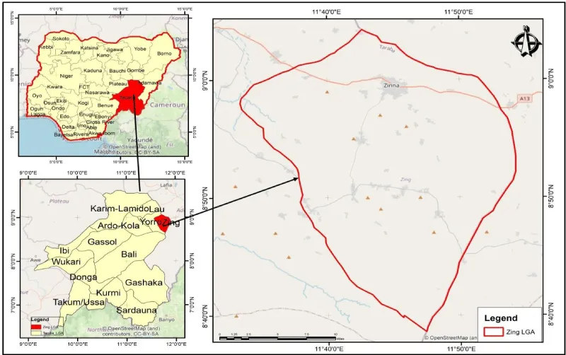
The study was carried out in Taraba State, Nigeria’s Zing Local Government Area. Zing is located between longitudes 11°35’ and 11°50’ east and latitudes 8°45’ and 9°10’ north. Its borders are Mayo-Belwa and Jada Local Government Areas of Adamawa State to the east and north, and Yorro Local Government Area to the west and south (Figure 1). Its entire land area is 867 km2, and its population is 127 362, growing at a 3.0 percent yearly pace [62]. The research area is divided into 6 districts with 75 large villages, each of which has between 257 and 783 farm families [63].
Zing usually experiences a tropical climate with distinct dry and wet seasons. The region’s mean annual rainfall ranges from 819 to 1761 mm. It lasts from April through October for a period of seven months. The rainy season begins in April with a light quantity of precipitation that progressively builds to a maximum in August before ceasing in October. The research area is part of the Savannah grassland belt, specifically the Guinea Savannah sub-region, which is distinguished by sporadic, tall, deciduous trees with broad leaves and tall grasses.
The hydromorphic and ferruginous tropical soils are the main types of soil. Local variations in altitude and human intervention have a significant impact on the soils. Loams and sands make up the soil type, and deep loamy soils can be found between rocks on the mountainous terrain. Clay loam soils found along streams and rivers’ banks enable a variety of local crops to flourish. The study area can be divided into two zones based on relief configuration: highland |mountain range and lowlands. The Atlantica, Shebshi, and Adamawa massif ranges are among the mountain chains that make up the highlands, which cover much of the southern region and extend from west to south. The majority of the villages in the area are located in the lowland, which makes up around 60% of the area. A variety of cereals are grown by the farmers in the study region, but the main food crops grown there include yam, sorghum, Bambara nuts, groundnuts, millet, tomato, beans, cassava, sweet potato, maize, and rice.
Primary and secondary sources combined to provide the study’s data. The primary sources of information were primarily farmers. Thus, field research, in-depth interviews with chosen farmers, and other key informants served as the main data sources. Experts in soil and water conservation were consulted for information as part of the primary data collection, while secondary sources of information used in this study were 2021 Landsat Imagery for Zing LGA.
A structured questionnaire was created using data from casual conversations with farmers and field observations, and 183 farm homes were randomly chosen for the study. A standardized survey questionnaire was used to collect farmers’ opinions on the issues with soil erosion and their conservation practices. Both open-ended and closed-ended questions are included in the questionnaire. The survey was divided into four key topics: (1) respondents’ household demographic factors; (2) respondents’ land and landholding characteristics; (3) causes and effects of erosion; and (4) respondents’ knowledge and behaviors regarding conservation.
The Statistical Package for Social Sciences (SPSS) version 23 was used to examine the results of the evaluation of farmers’ perceptions of the causes and effects of soil erosion in the Zing Local Government Area. Using ArcGIS 10.3, land use/land cover and topographical variables (elevation, slope, drainage density, aspect, curvature, flow direction, and flow accumulation) were examined and classed to estimate spatially explicit soil erosion in Zing Local Government Area. The final Erosion Risk Map was created using a weighted overlay analysis after the Analytical Hierarchy Process (AHP) was used to calculate weights for each variable. Using locational data on farmers’ perceptions of soil erosion and an erosion risk map created with the ArcGIS Statistical tool, a comparison between the farmers’ perceptions of soil erosion and the estimated soil erosion in the Zing Local Government Area was made. Next, the farmers’ conservation efforts against soil erosion in the Zing Local Government Area were evaluated. The Statistical Package for Social Sciences (SPSS) version 23 was used to examine the structured digital questionnaire’s results for conservative measures of soil erosion.
Results and discussions
Farmers’ perception of the causes/ effect of soil erosion in Zing Local Government Area
Table 1 lists the gender, age, marital status, religion, level of education, size of the household, and estimated revenue from agricultural products as well as the size of the farm. It reveals that 68% of respondents are male farmers and 32% are female farmers; 4% of respondents are between the ages of 20 and 30; 7% are between the ages of 31 and 40; 21% are between the ages of 41 and 50; 50% are between the ages of 51 and 60, and 18% are between the ages of 61 and 70; 79% of respondents identify as Christians, while 21% identify as Muslims. 14% of respondents have non-formal education, 39% have post-secondary education, 7% have a primary school education, and 39% have secondary education. It also reveals that 5% of respondents have households with two people, 12% have three people, and 15% have four people. Similarly, 21% of respondents have households with a size of 7, 16% have households with a size of 6, 19% have households with a size of 5, and 12% have households with a size of 8 or higher.
It further reveals that just 14% of farmers in Zing cultivate on land that is smaller than 1 hectare, compared to 46% who do so on land that is between 1 and 2 hectares, 18% who do so on land between 2.1 and 3 hectares, and 21% who do so on land between 3 and 4 hectares.
Farmer’s perception of soil erosion
The farmer’s knowledge of erosion types, causes of erosion, awareness of the soil erosion taking place on their farmlands, and perceived effect of soil erosion on their farmlands are presented in Tables 2a-2d.
Table 2a shows that all the farmers in Zing LGA have knowledge of the various types of erosion. It shows that 72 respondents have knowledge of rainfall, 7 of soil erosion, 39 of sheet erosion, 39 of rill erosion, and 26 have knowledge of gully erosion. This implies that the knowledge and perception of the farmers must be taken into consideration for a sustainable solution to the soil erosion problem. This agrees with Barnes 2013 [60]; Gruver & Weil [61] that the development of proper soil conservation policies that have the backing of farming communities is the primary requirement for achieving sustained soil conservation measures
Table 2b displays the farmers’ understanding of the factors that contribute to soil erosion in the research area. Most respondents in Lamma, Bitako, and Yakoko mentioned heavy rainfall, continuous cultivation, overgrazing, and poor farming practices as the causes of soil erosion, while wards like Zing B, Zing A2, Dinding, Bubong, and Zing A1 listed motorcycle, rainfall, overgrazing, deforestation, wind, runoff, and over-cultivation as causes of soil erosion in their far-flung areas. This result is congruent with Lal [5] that the primary causes of soil erosion are poor land use management techniques, deforestation, topography, and the climate in terms of rainfall and wind. It also agrees with Pimentel and Burgess [64], that soil erosion threatens food production and Borrelli, et al. [65] that the major anthropogenic drivers of erosion are land use and potential climate change through a more intense hydrological cycle.
Table 2c displays respondents’ opinions on how soil erosion has affected farms in Zing LGA. It reveals that 14% of farmers in the Zing Local Government Area (LGA) believed that soil erosion was occurring due to poor crop and grass growth, 11% believed it was occurring due to slope steepness, another 11% believed it was occurring due to soil stoniness, 7% believed it was occurring due to the development of rills and gullies, 46% believed it was occurring when plant roots started to show, 7% believed it was occurring when sheet erosion developed, and 4% believed it was occurring when yields This supports the findings of Lamers, et al. [66], who found that the majority of soil erosion is caused by the exposure of plant roots.
Table 2d displays how farmers evaluate the impact of soil erosion on their agricultural holdings. According to the study, 32% of respondents saw a decrease in arable land as a result of soil erosion, while 17% saw a gradual decrease in agricultural yields as well as a loss of vegetative cover and grasses as a result of soil erosion. However, 12% of the respondents saw soil erosion as having an impact on cropland productivity loss, and 9% saw soil erosion as having an impact on the submergence of productive arable land. In addition, 6% of respondents identified high input and management requirements as a result of soil erosion, 3% identified irrigation channel blockages as a result of soil erosion, and 2% identified outmigration, food insecurity, and poverty as a result of soil erosion in Taraba State’s Zing LGA. According to the findings, farmers’ experience indicates that the loss of arable land is the primary consequence of soil erosion, which is followed by yield decline over time, loss of flora and grasses, and decreased crop output. This agrees with Bekele & Gemi [67] in their research” Soil erosion risk and sediment yield assessment with universal soil loss equation and GIS: in Dijo watershed, Rift valley Basin of Ethiopia” and Sun, et al. [68] in the study Effects of vegetation cover and slope on soil erosion in the Eastern Chinese Loess Plateau under different rainfall regimes.
The types of tools used to till the soil are displayed in Table 2e. According to the results, 23% of farmers use a tractor and a hoe, while 34% utilize land plowing and harrowing. Similarly to this, 4% of farmers employ animal traction while 16% of farmers use heap raising to till the soil. When these findings are contrasted with those of Capello, et al. [69] and Mohieddinne, et al. [70], it becomes clear that utilizing large machinery to till the soil has a negative impact on its quality. Tillage alters soil structure by fracturing the soil, which speeds up surface runoff and soil erosion. Additionally, crop residue is reduced through tillage, which lessens the impact of pelting showers. And these generally indicate that over time, tilling activities in the Zing LGA exposed the soil to erosion.
Estimation of spatially explicit soil erosion in Zing Local Government Area
This involves analyzing soil erosion risk in Zing LGA, Multi-criteria analysis was adopted using the Analytical Hierarchy Process (AHP) method. The AHP was performed using the Digital Elevation Model (DEM), Land use/land cover, NDVI, Slope, and Stream Order of Zing LGA.
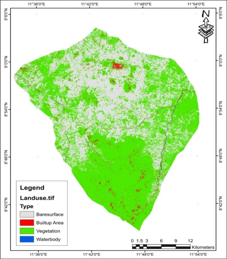
Figure 2 shows the land use land cover of Zing LGA with the ash portion representing the bare surface, the red portion representing the built-up area, the green portion representing vegetation, and the blue representing the water body. From figure 2, the southern and southeastern parts of Zing still have good vegetation coverage while the northern axis of Zing is largely characterized by bare surfaces with a concentrated built-up in Zing town, the LGA administrative headquarters while scattered or pockets of built-up areas could be seen in the south. This implies that Zing people are beginning to find serious comfort in living on the highlands and mountains which contributes to soil erosion from hillside cultivation activities.
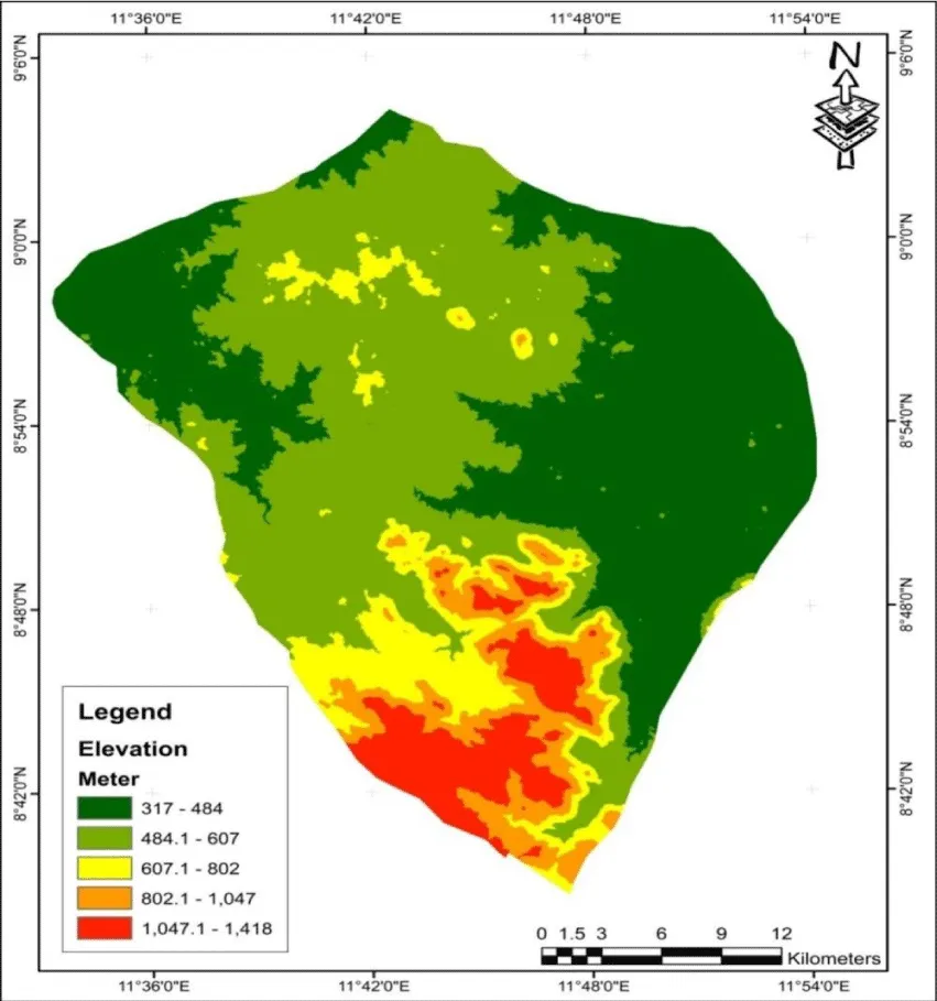
Figure 3, shows the digital elevation of Zing LGA with an elevation value of 317 to 1,418 meters above sea level. Figure 3 reveals that the highest point in Zing LGA is the southern part represented with dark red (1,047.1 – 1,418), followed by light red (802.1 – 1,047), the yellow portion (607.1 – 802), light green chloropleth from the central part of Zing LGA to the North (484.1 – 607) while the lowest point is represented by the dark green portion at the eastern and North-western part of the study areas. According to Baskan [71], low elevations are highly erodible, this reveals that the eastern and North-western parts of the study areas are liable to be affected by erosion followed by the Northern part and then the southern part of Zing.
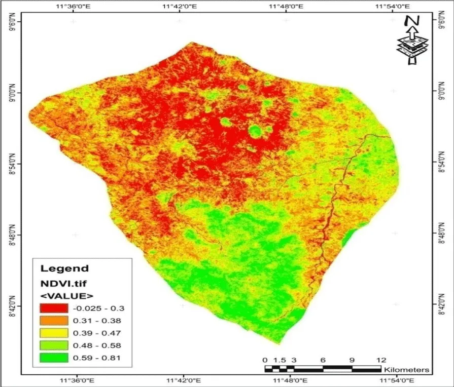
Figure 4 shows the normalized difference vegetative index of Zing LGA. It reveals that the NDVI of Zing LGA ranges from -0.025 to 0.81. Furthermore, it shows a high vegetation area towards the south and low vegetation northward. This reveals that the north without more vegetative cover is subject to being eroded than the southern part [72-75].
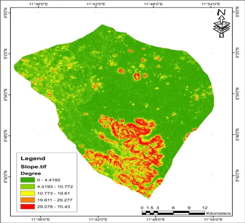
Figure 5 shows the slope or gradient of Zing LGA. It reveals that the slope of Zing LGA ranges from 0 degrees to 70.43 degrees with the steepest slope at the southern part while the north has an undulating plain slope. This shows that as populations are moving towards the south, more erosion is prone to occur there in the future as it is now in the North.
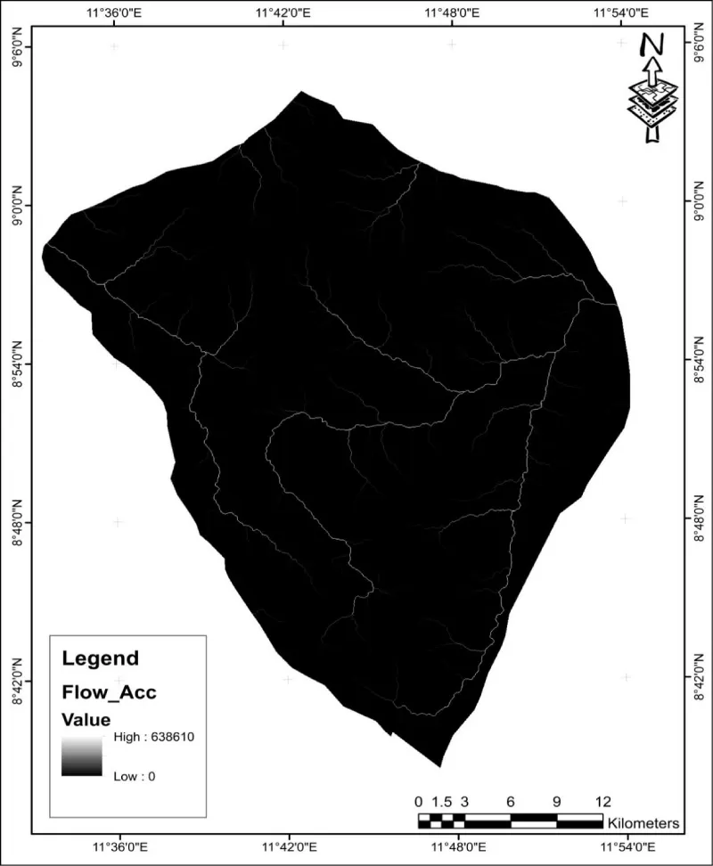
Figure 6 reveals the flow accumulation of Zing LGA. From Figure 6, the flow accumulation is 0 - 638610
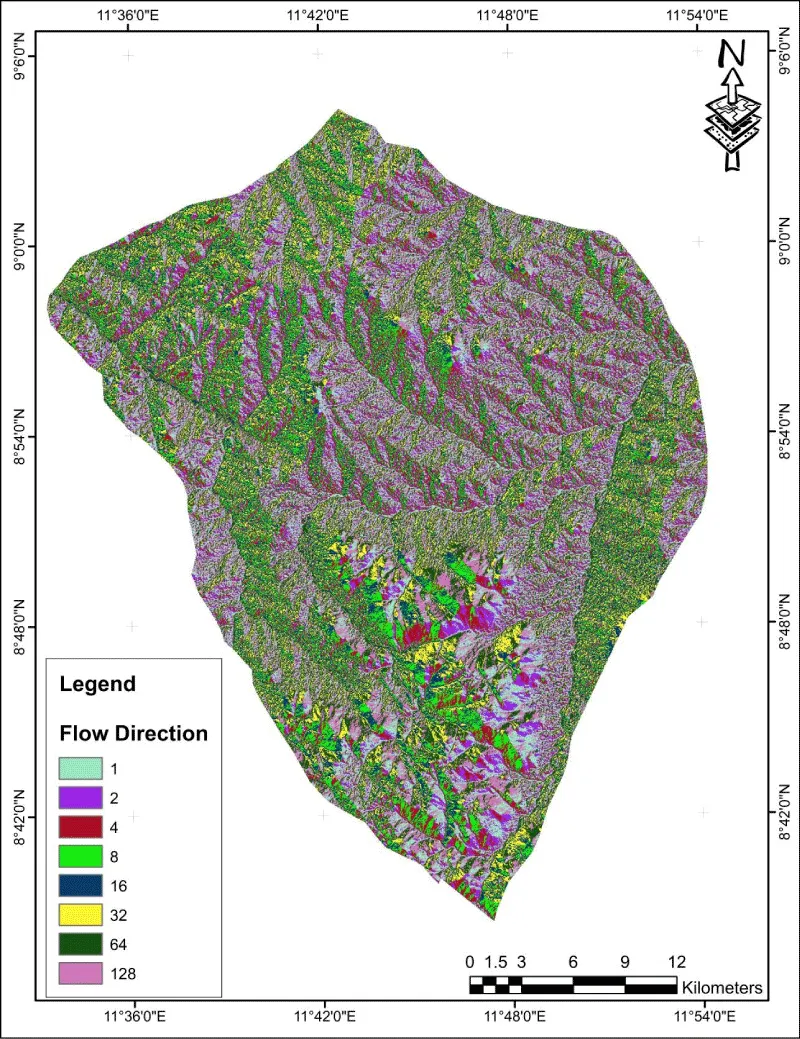
Figure 7 reveals the flow direction of Zing LGA. With 1 representing the East direction of flow, 2 representing the South-east Direction, 4 representing the south direction, 8 representing the south-west direction, 16 representing the west direction, 32 representing the North-west direction, 64 representing the north direction while 128 representing North-east direction of flowing in the study area.
Weighted overlay and final soil erosion risk
i. Criteria ranking using AHP Table 3.
The criteria used for this analysis were ranked based on expert knowledge of the factors influencing erosion.
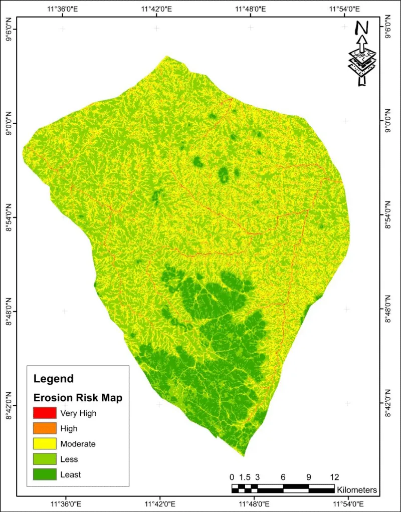
Figure 8 shows the gully risk of Zing LGA with the red portion as a Very High erosion risk zone, light red High erosion risk zones, the Yellow portion Moderate Erosion risk zones, light green as less erosion risk zones, and dark green as the least erosion risk zones.
Table 4 shows the comparative analysis of farmers’ perception of soil erosion risks based on agricultural practices in Zing LGA. It is evident that the use of animal traction has a lesser risk of erosion while the use of a tractor possesses the highest risk of soil erosion in Zing LGA.
The Table 5 shows the respondent’s awareness level of the type of soil erosion taking place in Zing and the nature of farmlands in the area. It is evident that poor crop and grass growth is perceived to contribute a great deal to high soil erosion in the area. The steepness of the slope is the next perceived factor contributing to soil erosion in Zing LGA while the least perceived factor contributing to soil erosion in Zing LGA is the period when there is a drop in the yield of crops.
Table 6 shows the local strategies used by farmers in Zing local government area to control soil erosion on their farmlands. These include the construction of bunds and forming irrigation to allow easy water passage, filling the affected area with farm residues, fencing the farmlands, and gathering stones around the land to be cultivated as the major ways.
Conclusion and recommendation
It is presented a study on farmers’ perceptions of soil erosion and soil conservation strategies. According to research and farmers’ observations, the loss of arable land is the primary consequence of soil erosion, which is then followed by yield decline over time, loss of grass cover, and decreased crop output (s). It also demonstrates that utilizing large machinery to till the soil has a detrimental effect on the quality of the soil. Tillage alters soil structure by fracturing the soil, which speeds up surface runoff and soil erosion.
Additionally, crop residue is reduced through tillage, which lessens the impact of pelting showers. And these generally indicate that over time, tilling activities in the Zing LGA exposed the soil to erosion. The erosion risk map reveals that areas with bare ground, near proximity to water, a lower elevation, and a low degree of the slope are more susceptible to erosion than other areas. Therefore, the following suggestions are made in order to manage and control soil erosion: through mulching, growing a cover crop, such as winter rye in food gardens, and maintaining a healthy perennial plant cover. Included are annual grasses, tiny grains, legumes, and other plant species that are cultivated to act as temporary vegetative cover.
In addition to serving as a “green manure” crop, cover crops are frequently tilled under. Other erosion controls, such as the use of geotextile materials or other techniques like sodding or hydroseeding that result in the establishment of permanent cover, are used to address problem areas that produce a lot of stormwater runoff. These techniques include placing the crushed stone, wood chips, and other similar materials in heavily used areas where vegetation is difficult to establish and maintain. Redirecting stormwater and roof runoff to places where it can settle and diffuse, like a rain garden, is one way to address these problem areas.
- Wassie SB. Natural resource degradation tendencies in Ethiopia: a review. Environ Syst Res. 2020; 9: 33. https://doi.org/10.1186/s40068-020-00194-1
- Sonneveld BGJS, Keyzer MA. Land under pressure: Soil conservation concerns and opportunities for Ethiopia. Land Degradation and Development. 2002; 14(1): 5–23.
- Yusuf MB, Ojeh VN. Assessment of soil erosion in cultivated fields using a survey methodology for rills in the northern part of Taraba State, Nigeria, International Journal of Geography and Regional Planning Research. 2022; 30-47.
- Yusuf MB. Soil erosion: farmers' perception and - UM Students' Repository. 2017.
- Lal A. Conventional and Organic Farming: soil erosion and conservation potential for row cultivation. Geoderma. 2011; 12:23-32.
- Fuchaka R.Urbanization and Accelerated Erosion: The case of Effon-Alaye in Southwestern Nigeria. Seminar paper, Department of Geography, Obafemi Awolowo University, Ile-Ife, Nigeria. 2012.
- Kimaro W. Water Erosion Prediction Model. Research Journal of Soil and Water Conservation 2018; 11(4): 13-24.
- Mullan H. Variations in some physical properties and organic matter content of soils of coastal plain sand under different land use types. World Journal of Agricultural Sciences 2013; 5(1): 63-69.
- Obalum Q. A genetic classification of gullies in eastern Nigeria and its implications on control measures. Journal of African Earth Sciences. 2012; 9: 711-718.
- Lal A. Rainfall Temporal Variability and Erosivity in sub-humid and Humid Zones of Southern Nigeria. Land Degradation and Development. 2016;17 (5): 541-555
- Bakker Q. Soil Erosion by Water in the Tropics, University of Hawaii/HITAHR-CTAHR Research and Extension Series. 2017; 24: 173, 1982.
- Kagabo Z. Stratigraphy and Paleogeography of the Cretaceous and lower Tertiary in southern Nigeria. University of Ibadan press, Nigeria. 2013; 251 – 266.
- FAO. The State of Food Insecurity in the World, special world report of FAO-UN, Rome. 2011; 11-14.
- Haregeweyn N. The hydrogeological and geotechnical parameters as causative agents in the generation of erosion in rain forest belt of Nigeria. Journal of African Earth Sciences. 2015; 417-425.
- Chen V. Rainfall Temporal Variability and Erosivity in sub-humid and Humid Zones of Southern Nigeria. Land Degradation and Development. 2017;17 (5): 541-555
- Daniel T. Bio-Engineering Measures for Stabilizing Cut- Slopes of Dipayal-Mellekh road, Far Western Nepal, Bulletin of Department of Geology, Tribhuvan University, Kathmandu, Nepal. 2017; 79-88: 2007.
- Zaidel’man W. Palynologicaland Palaeoevironmental study of the Middle-Upper Maastrichtian Mamu Coal facies in Anamabra Basin, Nigeria. World Applied Science Journal. 2009; 7(12): 1566-1575.
- Kiage L. The ragging war, Floods, Erosion and Gully Ravage – Anambra state commissioned and published by Government of Anambra State, Nigeria. 2013; 223.
- Junge H. Hydrocarbon Potentials of the Anambra Basin: Geology, Geochemistry and Geohistory Perspectives. Proceedings of 1st PTDF (Chair) Senior in Geology, University of Nigeria, Nsukka. 2009; 110.
- Pimentel D. Soil Erosion: A Food and Environmental Threat. Environment, Development and Sustainability. 2006; 119–137
- Pimentel D, Burgess M. Soil Erosion Threatens Food Production. Agriculture. 2013; 3(3):443-463. https://doi.org/10.3390/agriculture3030443
- Scherr SJ. Soil Degradation: A Threat to Developing-Country Food Security by 2020. International Food Policy Research Institute 2033 K Street, N.W.Washington, DC 20006-1002 U.S.A. 1999.
- Meshesha J. Determinants of farm – level soil conservation and erosion control adoption and utilization behaviours in the ecologically vulnerable areas of Imo State, Nigeria. Journal of Rural Development. 2012; 24 (4): 521 – 543.
- Lal A.Mathematical Soil Erosion Modeling, Water Interactions with Energy Environment, Food and Agriculture- Encyclopedia of Life Support Systems. 2018; 2: 1-3.
- Ananda J, Herath G. Soil erosion in developing countries: a socio-economic appraisal. Journal of Environmental Management. 2003; 68: 343 -353.
- Bindraban S.The Bida Basin in north-central Nigeria: Sedimentology and petroleum geology, Journal of Petroleum and Gas Exploration Research. 2012; 001-013.
- Bojö V. Review of the Basement Geology of South-western Nigeria, a review, in Geology of Nigeria, edited by C. A. Kogbe. 2016; 39-56. Elizabeth Publications Co., Lagos, 1976.
- Nyssen K. Rainfall Erosivity in Southeastern Nigeria. Ethiopian Journal of Environmental Studies and Management. 2009; 5 (2): 11-17.
- Ziadat O, Taimeh G. Gully Erosion Geohazards in Southeastern Nigeria and Management Implications. Sciencia Africana. 2013; 9(1): 20-36.
- Ziegler P. Analysis of a 36-Year Rainfall Data (1980-2015) for Erosivity Potential in Ikwuano Local Government Area of Abia State, Southeastern Nigeria. The Nigerian Journal of Cartography and GIS. 2016; 12(1&2): 87-101.
- Adebayo K, Tukur L.aring for the Land Best Practices in Soil and Water Conservation in Beressa Watershed, Highlands of Nigeria. Tropical Resource Management Papers. 2013; 76.
- Thapa I,Yila E. Review of Gully erosion in Nigeria: Causes, Impacts, and Possible Solutions. Journal of Geosciences and Geomatics. 2012; 2(3): 125-129.
- Tukur W. Review of the Basement Geology of South-western Nigeria, a review, in Geology of Nigeria, edited by C. A. Kogbe. 2014; 39-56, Elizabeth Publications Co. Lagos.
- Chukwuka S, Omotayo D. Soil Erosion Modeling. Encyclopedia of Agrophysics, Springer. 2009; 746-747.
- Henao W, Baanante T. Gullying processes in south eastern Nigeria. The Nigerian Fields, 2009; 64-74.
- Abayomi R. Land Degradation, Poverty and Marginality. In Marginality. 2012; 181-202. Springer Netherlands.
- FAO. SLM in Practice.promoting Knowledge on Sustainable Land Management for Action in Sub-Saharan Africa Roma, Food and Agriculture Organization of the United Nations. 2013.
- Salako I. Hydraulic Properties in relation to morphology of a tropical soil with hardened plinthite under time land use types. Tropical and Sub-tropical Agro Ecosystems. 2016; 8 (4): 145-155
- Ray Q, Yusuf U. Soil Erosion and Environment In China, Science Press, Beijing. 2011; 355.
- Tekwa Q,Usman K. Gully Erosion Geohazards in Southeastern Nigeria and Management Implications. Scientia Africana. 2016; 9.
- Hurni R. geotechnical characteristics of soils susceptible to severe gullying in eastern Nigeria. Bul.Of International Asso.Of Engineering Geology. 2018; 111-119.
- Ericksen Q, Ardón R. Controlling Soil Erosion Problems in Anambra State through Attitudinal Change, in Developing a Friendly and Sustainable Environment: The Global Challenge Proceedings of the Annual Conference of Environment and Behaviour Association of Nigeria (EBAN). Held at NnamdiAzikiwe University, Awka, from Nov. 12th – 14th. 2013.
- Malgwi I, Abu E. Soil erosion: a food and environmental threat. Environment, Development and Sustainability. 2011; 8(1): 119-137.
- Shankarnarayan L.Global Assessment of land degradation and Improvement, Identification by remote sensing. Report 2008/01, ISRIC, Wageningen. 2015; 26-36.
- Hudson S. Performance of gully eroson control measures in south eastern Nigeria. Proceeding of the International Symposium on Forest Hydrology and Watershed Management, Vancouver, Canada. IAHS Publication. 2009; 167:163-172.
- NEST. Soil Loss estimation using GIS and remote sensing techniques: A cast of Koga watershed, Northwestern Ethiopia. International Soil and Water Conservation 1996; 4: 126-136.
- Olatunji T. Macro-analytic study of the impact of gully erosion in Old Imo State of Nigeria. American Journal of Geographic Information Systems. 2013; 1(2): 23 – 32.
- Yusuf MB, Ray HH. Farmers’ Perception and Reponses to Soil erosion in Zing Local Government Area of Taraba State, Nigeria, Ethiopian Journal of Environmental Studies and Management. 2011; 93-98.
- Bewket L, Sterk F.Gully Erosion Control, Ontario Ministry of Agriculture, Food and Rural Affairs. 2012.
- Fairhead W, Scoones R. Nigeria’s Threatened Environment. National Profile. Nigeria Environment Study Action Team, NY: John Willy and Sons. 2015; 48-54.
- Moges I. Performance of gully erosion control measures in southeastern Nigeria. Forest Hydrology and Watershed Management. 2013; 167 (4): 163-172.
- Okoba U, de Graaff Y. Wetland of southeastern Nigeria: Extent and Characteristics. Nigerian Journal of Agriculture, Food and Environment. 2015;5(2-4): 42-46.
- Assefa H, Hans-Rudolf U. An Assessment of the Socio Economic Impacts of Soil Erosion in South-Eastern Nigeria, Shaping the Change, XXIII FIG Congress Munich, Germany. 2016; 12:2006.
- Amsalu B, de Graaff Y. Land Degradation and Livelihood in Semiarid India: A Study of Farmers’ Perception in Chambal Valley. Asian Profile. 2016; 39: 505–519.
- Knowler D, Bradshaw B. Farmers' adoption of conservation agriculture: A review and synthesis of recent research. Food Policy. 2007; 32:25-48.
- Okoba I, Sterk W. GIS analysis for Mapping Gully Erosion impacts on the Geo-formation of the old Imo State, Nigeria. ABSU Journal of Environment, Science and Technology. 2016; 1: 48-61.
- Bewket A. Geology and Mineral Resources of Nigeria, London: Springer Dordrecht Heidelberg. 2011; 5-14: 2009.
- Dalton W. Gully Erosion in Southeastern Nigeria: Role of Soil Properties and Environmental Factors. Department of Soil Science, University of Nigeria, Nsukka, Nigeria. 2011.
- Odendo S. Land degradation: an overview. In Response to Land Degradation, eds. E. M. Bridges, I.D. 2010; 132-143.
- Barnes U. Genetic Classification of Gullies in eastern Nigeria and its Implication on Control Measure. Journal of African Earth Science. 2013; 8: 716.
- Gruver N, Weil Z. The Agulu-Nanka gully erosion menace in Nigeria: what does the future hold for population at risk? .Department of Geography, University of Nigeria, Nsukka. 2017.
- National population Commission (NPC). 2006 Census Result.
- Taraba Agriculture Development Agency, TADP. Taraba Agriculture Development Agency, Village listing book. 2014.
- Pimentel D, Burgess M. Soil Erosion Threatens Food Production. Agriculture. 2013; 3: 443- 463.https://doi.org/10.3390/agriculture3030443
- Borrelli P, Robinson DA, Panagos P, Lugato E, Yang JE, Alewell C, Wuepper D, Montanarella L, Ballabio C. Land use and climate change impacts on global soil erosion by water (2015-2070). Proc Natl Acad Sci U S A. 2020 Sep 8;117(36):21994-22001. doi: 10.1073/pnas.2001403117. Epub 2020 Aug 24. PMID: 32839306; PMCID: PMC7486701.
- Lamers J, van der Meer T, Testerink C. How Plants Sense and Respond to Stressful Environments. Plant Physiol. 2020 Apr;182(4):1624-1635. doi: 10.1104/pp.19.01464. Epub 2020 Mar 4. PMID: 32132112; PMCID: PMC7140927.
- Bekele B, Gemi Y. Soil erosion risk and sediment yield assessment with universal soil loss equation and GIS: in Dijo watershed, Rift valley Basin of Ethiopia. Modeling Earth Systems and Environment. 2021; 7(1): 273-291.
- Sun C, Hou H, Chen W. Effects of vegetation cover and slope on soil erosion in the Eastern Chinese Loess Plateau under different rainfall regimes. PeerJ. 2021 Apr 12;9:e11226. doi: 10.7717/peerj.11226. PMID: 33954047; PMCID: PMC8048402.
- Capello G, Biddoccu M, Ferraris S,Cavallo E. Effects of tractor passes on hydrological and soil erosion processes in tilled and grassed vineyards. Water. 2019; 11(10): 2118.
- Mohieddinne H, Brasseur B, Spicher F, Gallet-Moron E, Buridant J, Kobaissi A, Horen H.Physical recovery of forest soil after compaction by heavy machines, revealed by penetration resistance over multiple decades. Forest Ecology and Management. 2019; 449: 117472.
- Baskan O. Analysis of spatial and temporal changes of RUSLE-K soil erodibility factor in semi-arid areas in two different periods by conditional simulation. Archives of Agronomy and Soil Science. 2021; 1-13.
- Strahler AN.The nature of induced erosion and aggradation. In Environmental Geomorphology and Landscape Conservation. 2020; 18-35. Routledge.
- . Odoemenem R, Obinne R. Threats and Mitigation of Soil Erosion and Land Degradation in Southeast Nigeria. Journal of Environment and Earth Science .2010; 3(13): 95-102.
- Kolawole Y. Geotechnical investigations for design of foundations for erosion and flood control structures at Unwana Beach, Afikpo, Ebonyi state, Southeastern Nigeria. Fifth International Conference on Case Histories in Geotechnical Engineering. 2013.
- Bewket Q. Geology of the Southern Anambra Basin, In: Reijers, T.J.A, selected chapters on Geology, SPDC, Warri. 133-148: 1986.
Article Alerts
Subscribe to our articles alerts and stay tuned.
 This work is licensed under a Creative Commons Attribution 4.0 International License.


 Save to Mendeley
